|
 As the maps and
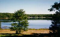
pictures from the prior page show (you did get your map, didn't you?), Wauwepex is centered around Deep Pond, a
20-acre picturesque body of water fed by an underground spring. The camp
is basically spread out in two arms that encircle the lake. Like Onteora,
Wauwepex was once divided into three camps, each with a dining hall and
waterfront. In addition to tent platforms and the cabins, there are also
numerous lean-to's around the property. As the maps and
pictures from the prior page show (you did get your map, didn't you?), Wauwepex is centered around Deep Pond, a
20-acre picturesque body of water fed by an underground spring. The camp
is basically spread out in two arms that encircle the lake. Like Onteora,
Wauwepex was once divided into three camps, each with a dining hall and
waterfront. In addition to tent platforms and the cabins, there are also
numerous lean-to's around the property.
As you drive onto the camp property, you'll
pass the ranger's house off to your left. Just past that, also on the
left, is the Hendrickson Service Building, site of the maintenance shops.
This, in turn, brings you to a crossroads. Off to the left the road leads
to Hickox Dining Hall, and to the right, Hayden Hall. We'll continue
through the intersection and head down towards the lake.
 After
passing the parking lot on your left, you can spot the camp's Health Lodge
through the trees on the left. Due to a change in New York State laws, the
building can no longer be called a health lodge, so it's now known as the
Grace Building. It's one of the older buildings on the property, and I
believe the name restriction is due to a lack of handicap access. The
building has a basement, used for storage, and years ago I found an
ancient candlestick phone down there. I still have it, and someday hope to
find the parts to restore it. After
passing the parking lot on your left, you can spot the camp's Health Lodge
through the trees on the left. Due to a change in New York State laws, the
building can no longer be called a health lodge, so it's now known as the
Grace Building. It's one of the older buildings on the property, and I
believe the name restriction is due to a lack of handicap access. The
building has a basement, used for storage, and years ago I found an
ancient candlestick phone down there. I still have it, and someday hope to
find the parts to restore it.
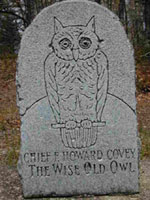 Next
you'll come to a small field that looks like it was once used as a parade
ground. The most interesting thing here is a memorial to F. Howard Covey,
"The Wise Old Owl". Looking for all the world like a tombstone,
it marks were Covey, one of the founders of Buckskin
Lodge of the Order of the Arrow, watched as the Scouts passed by in
parade. There's a small plaque underneath the stone marker that supposedly
tells you all this, but it's so worn from the weather that it's impossible
to read now. I used to have a copy of the wording and if I can find it
I'll add it to the site. Can anyone else help? Next
you'll come to a small field that looks like it was once used as a parade
ground. The most interesting thing here is a memorial to F. Howard Covey,
"The Wise Old Owl". Looking for all the world like a tombstone,
it marks were Covey, one of the founders of Buckskin
Lodge of the Order of the Arrow, watched as the Scouts passed by in
parade. There's a small plaque underneath the stone marker that supposedly
tells you all this, but it's so worn from the weather that it's impossible
to read now. I used to have a copy of the wording and if I can find it
I'll add it to the site. Can anyone else help?
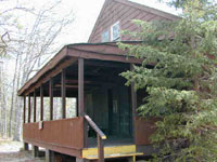
There are several buildings off to the
right side of the road. many of these have been used for different
purposes over the years. What is listed as the Camp Office on the 1950 map
is now the Christiansen Cabin. The former Craft Lodge is now the T.R.
Pavilion, which hosts an indoor BB gun range. The former Trading Post is
now the Smith Training Center, with a nice view of the lake.
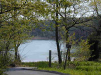 Just
before you get to the lake you can spot a marker for the beginning of the
camp's Ecology Trail. Running around the lake, it offers hikers a chance
to learn more about the flora and fauna of the area. Several stations have
been set up to explain what is in the area, and Scouts can earn patches
for completing the trail and answering questions on what they have
observed. Trail guides are available in the Trading Post when the camp is
in operation. Just
before you get to the lake you can spot a marker for the beginning of the
camp's Ecology Trail. Running around the lake, it offers hikers a chance
to learn more about the flora and fauna of the area. Several stations have
been set up to explain what is in the area, and Scouts can earn patches
for completing the trail and answering questions on what they have
observed. Trail guides are available in the Trading Post when the camp is
in operation.
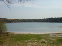 Finally,
we arrive at the lake. Back in the 50's this area was the site of an
amphitheatre and dock, but all signs of both are long gone. All that
remains today is a sandy beach. This view looks across the beach to the
other side of Deep Pond, where the swimming dock is set up in Summer
(these pictures were taken April 10, 2000, so the camp was not in
operation). Off in the woods to the right of this picture you might find
the crumbling foundation of the camp's first dining hall. Finally,
we arrive at the lake. Back in the 50's this area was the site of an
amphitheatre and dock, but all signs of both are long gone. All that
remains today is a sandy beach. This view looks across the beach to the
other side of Deep Pond, where the swimming dock is set up in Summer
(these pictures were taken April 10, 2000, so the camp was not in
operation). Off in the woods to the right of this picture you might find
the crumbling foundation of the camp's first dining hall.
The beach is a nice spot to spend a few
minutes enjoying the animals that live in the camp. Raccoon and deer
tracks are easy to spot, and we found some baby turtles during our recent
visit. There are often some beautiful butterflies and birds passing by,
making it a nice retreat from the homes and businesses that now circle the
property.
For the 2000 season, the camp waterfront
was moved back to this area after many years at the far end of the lake.
Ready for a tour around Deep Pond? Click here
to continue the tour, and to find out how deep the pond actually is. You
can also click here to return to the main Onteora
page.
|