We'll
continue the tour by hiking around Deep Pond. There's the remnants of a
once-paved road that circles the lake, and we'll head off in a clock-wise
direction. The camp's Ecology Trail follows much of this route, so keep
your eyes open a look at the local inhabitants!
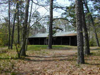
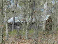 Up
on the hill to your left, just after starting on the hike, is Buckskin
Cabin, another of the older structures still in use at the camp. Most of
these cabins can be rented for weekend use throughout the year, providing
an excellent opportunity for year-round camping. My old troop used to
spend many weekends at Wauwepex, and the cabins were definitely the way to
go in winter. If I remember correctly, all cooking was done outdoors, so
they're fairly primitive. They do feature a nice supply of bunks, and some
have fireplaces. Up
on the hill to your left, just after starting on the hike, is Buckskin
Cabin, another of the older structures still in use at the camp. Most of
these cabins can be rented for weekend use throughout the year, providing
an excellent opportunity for year-round camping. My old troop used to
spend many weekends at Wauwepex, and the cabins were definitely the way to
go in winter. If I remember correctly, all cooking was done outdoors, so
they're fairly primitive. They do feature a nice supply of bunks, and some
have fireplaces.
Up
ahead on the right is another small beach. The site of the current fishing
dock for summer campers, this was once the swimming area for the camp's
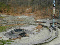
Pioneer Division. Continuing past the beach we'll come to the Stone
Campfire Ring on the left. This campfire ring is very old, and is
constructed out of good-sized rocks cemented together. Being made of stone
it has survived where many of the other campfire areas at both Onteora and
Wauwepex have been reclaimed by nature. At the head of the ring is a
throne-shaped chair, visible in this picture just to the left of the totem
pole. Can you just imagine how many songs have been sung around here over
the years, or how many ghost stories have scared new campers silly?
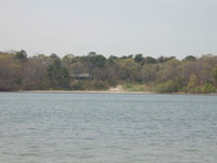 The
next milestone on the hike will be the Jewish Chapel, just past the
campfire ring, and then we come to yet another beach. This is the former
Frontier Division waterfront, and is now the site of all swimming and
boating activities for the camp. This view is looking across Deep Pond
towards the beach where we started, with the Smith Training Center (old
Trading Post) visible through the trees. The
next milestone on the hike will be the Jewish Chapel, just past the
campfire ring, and then we come to yet another beach. This is the former
Frontier Division waterfront, and is now the site of all swimming and
boating activities for the camp. This view is looking across Deep Pond
towards the beach where we started, with the Smith Training Center (old
Trading Post) visible through the trees.
While we're resting here at the edge of the
lake, it's time to answer the question - how deep is Deep Pond? About
39-40 feet in most places, which may not sound particularly deep until you
realize that most ponds on Long Island are less than 10 feet deep.
Whatever glacier carved out Wauwepex's lake went unusually deep, leaving
us one of the nicer bodies of water on all of Long Island.
 At
both sides of the waterfront area you'll find some tall grass growing out
of the water. While they look pretty, the plants are not native to the
area, and the camp is trying to find a way to get rid of them. It's quite
a problem, as the herbicides have to pass State approval and not harm any
of the native plants, so up to now, the plants have been holding their
own. There are some advantages, as they provide shelter to some small
animals, but unless checked they will squeeze out the local plants. At
both sides of the waterfront area you'll find some tall grass growing out
of the water. While they look pretty, the plants are not native to the
area, and the camp is trying to find a way to get rid of them. It's quite
a problem, as the herbicides have to pass State approval and not harm any
of the native plants, so up to now, the plants have been holding their
own. There are some advantages, as they provide shelter to some small
animals, but unless checked they will squeeze out the local plants.
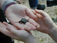 Here's
one of the local inhabitants - a baby red turtle. The beach here was
covered with animal tracks, and small fish could be seen at the water's
edge. More exciting, though, were signs of some larger fish, particularly
a few jumping out of the water. It looks like the State's efforts in
stocking the lake are paying off. Here's
one of the local inhabitants - a baby red turtle. The beach here was
covered with animal tracks, and small fish could be seen at the water's
edge. More exciting, though, were signs of some larger fish, particularly
a few jumping out of the water. It looks like the State's efforts in
stocking the lake are paying off.
Continuing on our trip, you'll next pass
the Protestant Chapel, and further long the trail, you can spot Sagamore
Cabin. This building is named for a honor camping group dedicated to
supporting the goals of the Council. Since they've never asked me to join,
I can't explain how one gets in or exactly what it is they do.
 Finally,
after passing the Smith Training Center/old trading post, we return to the
crossroads where we first set off for our jaunt around the lake. Finally,
after passing the Smith Training Center/old trading post, we return to the
crossroads where we first set off for our jaunt around the lake.
Rested up and ready for a look at the
dining halls, camp sites and C.O.P.E. course? Click here
to continue the tour. You
can also click here to return to the main Onteora
page.
|