
Ready to leave the lake area and start doing a little climbing? From the crossroads at the former Trading Post, let's continue on the road that just brought you over the bridge and head up the hill to Chiefs Camp. The small map on the right shows the road through Chiefs Camp highlighted in red to give you an idea of the area; click on the map for a larger version.
As you climb upward from the lake, there once were campsites on both sides of the road. Some of them were pretty far back from the road and tough to spot, especially the ones down the hill off to the right side of the road. By the time this map was printed all of the campsites on this road were gone except one, On-On-Tio. Click here for a list of all of the campsites in Chiefs Camp.
After a brief hike, you soon come to another crossroad. While the road ahead of you may be a bit overgrown at times, as seen in this 1998 view looking towards the Council House, it was once one of the busiest places in camp. If you go straight ahead, the road basically circles Chiefs Camp and comes back to this point. We'll continue heading straight, up the hill, for now, following the original route of the Old Hunter Road, an important trade artery constructed by John Hunter in 1815. First, though, off to the left at the crossroad is the Otter Program Shelter. There are a number of these shelters scattered across the property, and in many ways, they are the core of the summer camping experience.

Road to the Council House (1998)
Yes, while the lake is an important - and fun - way to pass part of a hot summer day, the shelters are the real reason the camp exists in the first place. Onteora is a summer camp, after all, and this is where Scouts learn how to camp. Staffed by 3-4 counselors, each shelter originally provided lessons in cooking, plant identification, knots, knife and Axe safety, map and compass skills, and more. There was also a chance to practice skeet shooting, archery and many other fun events. Each shelter served a number of campsites, with approximately 200 Scouts for each shelter at Onteora's peak.

Program Shelter (1970s)
Today the focus has shifted from the "one shelter serves all" concept to having specialized activities at each of the shelters, but these areas remain an important part of "The Land in the Sky."
Continue on not far past the Otter shelter and you'll find yourself at the Council House, the heart of Chiefs Camp. The Council House was the dining hall, store, shower facility and camping gear storage area for all of the campsites in Chiefs Camp. While most troops ate their breakfasts in their campsites, cooking for themselves, campers heading off for a day of hiking might begin their trip by gathering at the Council House for a flag raising ceremony and breakfast. For the other two meals of the day, troops would alternate in either having meals prepared by the kitchen staff delivered to the campsites in metal containers called "heater stacks", or eating at the dining hall. Meals there were usually followed by singing or other entertainment, making it a fun place to gather. The food was surprisingly good, especially when you consider how many mouths there were to feed in a very short period of time.

Council House (1998)
As mentioned, the Council House also housed a small store, which was mostly intended to supply food for campsite cooking, and a camping gear storage area, which was located underneath the store and next to the showers. The tents and other material stored down there must have been old by the time they were declared military surplus; venturing into this dark and damp area was always an adventure. The showers were another delight best left undescribed.

Council House (1983)
A number of these pictures, by the way, were taken in 1983. By that time attendance had dropped to the point where the camp no longer needed two dining halls, so the Council House, which had opened in 1960, was retired. It was sad to see the once bustling building shuttered, and weeds and grass overtaking the parking and assembly areas. Inside, it was like taking a trip back in time. Tables and benches were still in place, waiting for campers that were not to come. Overhead were dozens, if not hundreds, of wooden plaques left behind by patrols and troops of years past, listing their unit numbers, home towns and campsites. The kitchen looked like all it would need would be a good cleaning to be back in business. All that was missing was people. Sadly, by 1998 the years and vandals had taken their toll on the facility. The kitchen area was a disaster, and the less said about the store and storage areas the better. Most of the signs left by troops in earlier years had vanished, leaving bare rafters behind. The tables and benches were also history.

Ruins of the Council House Kitchen (1998)
During the 1990s there was a lot of talk about tearing down the Council House, but happily past members of the camp staff stepped up to help save the building, raising the money and contributing the labor to paint and then re-roof it. Some people thought we were out of our minds working to save a building with no foreseeable future, but we knew that once it was gone it would be next to impossible to replace it.
In recent years a lot of work has been done on the Council House. A new well was dug to supply water year-round, electricity was restored, and a great deal of interior work completed. While it is not used as a dining hall today, the Council House is once again a vibrant part of camp, providing a space for computer and STEM programs, as well as other rainy day activities. If you know the Catskills, you will appreciate that aspect.
The fellow who explored the camp with me and is pictured here, by the way, is Bill Throop. Bill worked in the camp office for several years, and he and I later became college roommates. He was also the best man at my wedding. I met Bill through the Boy Scouts way back in 1967 and we have remained close friends all these years. It's things like that friendship that make Onteora more than just some pretty real estate to me.

Bill Throop at the Council House (1983)
Just to the left of the Council House was a campsite used for Staff Training units, comprised of campers hoping to land a spot on the Onteora staff. Leaving the Council House area, the road continues past the building and loops through the Chiefs Camp, passing what where once more than a dozen campsites. Another special campsite was located on the way, that of the Junior Leader Training Corps. The JLTC units were comprised of Scouts from various troops and towns, and they spent a lot of time marching and building towers and rope bridges. Theirs and the Staff Training campsite were probably the cleanest and best maintained in the camp, due to the hard work of the campers. The only sign of these campsite in 1998 was one very weathered board nailed to a tree at the former Staff Training area.
KISMIF, by the way, stands for "Keep It Simple - Make It Fun". They sure got their money's worth out of that paint.

Junior Leader Training Corps Shelter (2009)
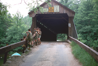
The JLTC once had their own program shelter, which was renamed the Bobcat Program Shelter by the time the map was printed (just to make it even more confusing, there was once a different Bobcat Shelter, which was in turn renamed the F. Howard Covey Program Shelter, only to be torn down). Continuing past the shelter, you'll come upon the Old Hunter Road once again. This leads to Rattle Hill, where several small caves can be explored, and off-site attractions such as Frick Pond, Beaverkill State Park and Alder Lake. There were some wonderful hiking destinations, such as this covered bridge at Beaverkill. (Click here for another picture of the bridge.) The stream is quite shallow and great for swimming or wading, making it a popular spot to have lunch and rest those aching feet. Several of the camp's trail guides, which have detailed descriptions of the trails and sights, can be found by clicking here.

Beaverkill Covered Bridge (1969)
Continuing past Old Hunter Road, you will pass the sites of numerous now-abandoned campsites, as well as the former site of the Bobcat/Covey Shelter, which is not shown on the map but was where the Blue Trail crossed the loop road. The shelter, which had been re-named for one of the founders of Nassau County Council and Camp Wauwepex, had become too run down to use and was either intentionally burned or torn down, and the concrete slab removed. All that remains of this particular shelter is a square patch of ground where the ferns that grow all over camp seem unable to re-establish themselves. Instead, a motley collection of various plants and a cleared area once used for archery are all the remains of the shelter, staff area and campsites.

Ruins of a latrine on the Council House Loop (2009)
Past this point the road has deteriorated to the point where the only vehicles that should attempt it are four-wheel drives or rental cars with full insurance and a driver with a death wish. You'll eventually come to a crossroads, leading either to Tribes Camp or continuing through the rest of Chiefs Camp. Passing Tribes Camp for now, you'll come to the Water Tank at the top of the Power Line Trail. When I was at camp there was a strict rule against throwing rocks at the water tank, with the explanation that the pounding rocks would cause rust to flake off and pollute the water supply. Personally, I think it was to keep from driving the campers in nearby sites from going crazy. I hate to think how much rust is in there now...

Intersection at the Water Tank (2009)
The road finishes the loop by heading back towards the Council House, joining itself once again at the Otter Program Shelter. Continue your tour with the menu below.
Tour pages


