

Located in the Catskill mountains, north of New York City, Livingston Manor is a fairly quiet place these days. Even back during the days I was camping at Onteora, Livingston Manor wasn't all that busy a place. The railroad had long since closed down and pulled up the tracks, and other than farming and tourism, I never saw any signs of a local industry. Today, the overall downturn of tourism in the Catskills hasn't helped things, and the region has become even sleepier (then again, Rip Van Winkle was from the Catskills!)
| Here's a general map of the area. Livingston Manor is best reached via NY Route 17, also known as "The Quickway". It's about a two hour drive from the New York City area. People who have only been in the metropolitan area will be surprised how soon the trip gets them into a pleasant rural setting. |  |
| Here's a very different map of the area. This one was a giant terrazzo map built for the New York State Pavilion at the 1964-1965 New York World's Fair. Based on an actual Texaco map of the state, the World's Fair version shows some of the lakes in the area, but for some reason not the camp's Orchard Lake, which is larger than the ones shown. The map also shows an airport just outside town. I wanted to fly over the area but didn't have my pilot's license while I was working at camp. The field closed in the early 1980s so I'll have to find another spot to rent a plane on a future trip. |  |
| Livingston Manor was a pleasant spot to head for on a day off as a counselor. During our Order of the Arrow trips and other visits, the Robin Hood Diner just off Route 17 was a convenient spot to rendezvous with friends before heading up into the hills for Onteora. If I remember correctly, one of the folks behind bringing the diner to Livingston Manor was Niles Fairbairn, who was a colorful character over at our Alder Lake camp. The diner is still there today, so drop in for a hot meal or cold beverage before heading up to camp. |
 |
| Where's Onteora in relationship to the town itself? Well, the closest thing on the map is Grooville. I hesitate to call it a town, for despite many trips through what the maps claim is Grooville, I never saw any hint of a town! Here's a closer look at the area, showing Orchard Lake, which is located within the grounds of Onteora. All of the roads shown near the lake are within the camp as well. | 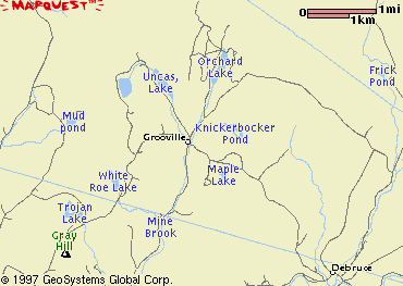 |