

Many thanks to John Parrot for sending me a copy of this trail guide; it was invaluable during my first trip back to Onteora in 1998 when I was starting this site. The guide is not dated, but appears to be from around 1963. It mentions the camp's Manor House, which was replaced in the mid-60's by the Administration Center. It also mentions an archery range built in 1961, so it has to be later than that.
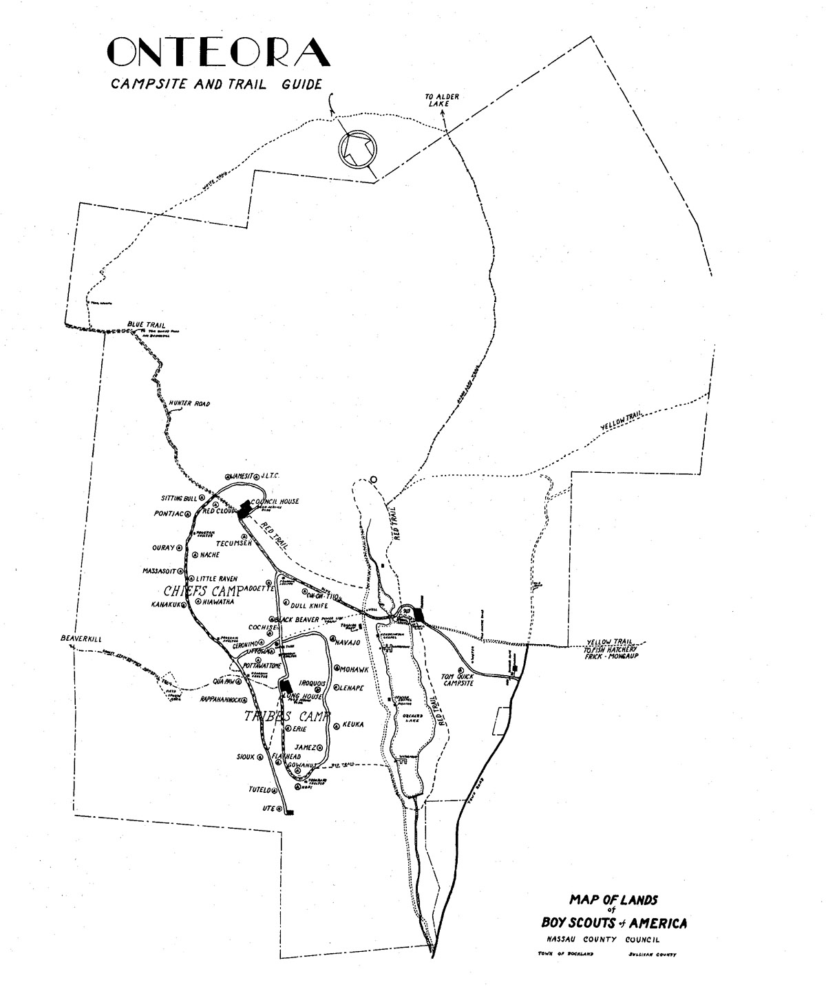
The first page of the guide is a map of the camp, which is somewhat different than all of the other maps I've seen. Click here for a copy. The guide also includes a poem, "Hiking Onteora", that you might enjoy. It's just a few lines further down.
The trails covered in this guide are the Red Trail, White Trail, Blue Trail, Yellow Trail, Alder Lake and the Ernest Steinbrenner Memorial Trail. That last one is new to me, as I have no recollection of it at all. It is never mentioned on later guides, and no sign was seen of it on a 1998 visit back to the camp. Here's how John Parrot describes it:
"You asked about the Ernest Steinbrenner trail: it was the "direct route" to Beaverkill; I remember hiking it several times, the first was in about 1962. It didn't have a name then, and it was more of a map and compass exercise than a trail. You just got out your topographic map, took a bearing, and you were off. A year or so later trail markers were put up, although the trail was very difficult to follow and the markers petered out about halfway. I remember that the trail was always in jeopardy due to trespassing/land ownership problems. There was a grazed field you had to cross well after you had left camp property, and while leading a group across one year we were chased by bulls."
One other change noted between this one and the other trail guide found on this site concerns the "Hiking Stump". The center of all trails at Onteora, the stump has moved quite a bit over the years! In this version of the guide it was located near the Manor House, and in later years was found at the Covey Hiking Shelter and now the Long House. Other changes noticed in my trip back to OSR in September 1998 are mentioned below.
It's time now to turn the clock back 50 years or so and re-hike these trails, at least in memory.
Introduction - SRR Index Card.
Hiking Stump - Trail begins.
MANOR HOUSE - This stately old house stands majestically on a hill overlooking Orchard Lake. It was the home of the New York Rod & Gun Club, and at one time was an exclusive mecca for the outdoorsman. The trail runs behind the small buildings opposite the Manor House where it joins with the Yellow Trail.
1998 update: The Manor House is, of course, long gone.
2001 update: The previous owner was actually "The Trout & Skeet Club of New York".
WILDCAT FALLS - This is probably one of the most beautiful water falls in the Catskills. During the summer months it is quite dormant, exposing its lining of shimmering stone walls, and its slippery bed of stone. There are several drops. In the early Spring, the water leaps wildly into space and lands with tremendous cascading force upon the apron. No wonder the Indians, inspired by this site called them Wildcat Falls.
DEVIL'S GORGE - The Red Trail goes past the remains of an old Monkey Bridge. The stream turns into a roaring demon in the early Spring, due to the melting snows. This follows the stream uphill to the bridge and goes into the woods, head toward the old skeet range.
SKEET RANGE, ROD & GUN CLUB - This was the former Skeet Range of the old Rod & Gun Club. However, this particular ground dates back further into history when a small settlement stood here. You can still see the foundations of former homes. The trail proceeds through the field and takes the road leading to the Catholic Chapel.
CATHOLIC CHAPEL - This was the first of the 3 chapels built. The other two are located on the lake, and built of the same design. The trail then leaves the road and proceeds uphill towards the Council House. Once you are on top of the hill you may spot a deer or two, if you are quiet.
1998 update: The chapel is no longer there, having been moved behind the Health Lodge for staff housing.
2022 update: The chapel deteroiated over the years and was razed.
COUNCIL HOUSE - This is the second Food Service Building constructed. It's first summer camp operation was the 1960 season. It serves the Chiefs Camp. Just north of the Council House is the Old Hunter Road.
OLD HUNTER ROAD - It is steeped in the history of the land, running east to west through camp. It was used in the past by the Indians in traveling from the Delaware to the Hudson. The trail follows this road to the Chiefs' trail, a distance of 50 yards.
CHIEF'S TRAIL - This is the newest road in camp. The trail follows along this road almost entirely, showing you many of the newer campsites. 50 yards from its junction with the Tribes Trail, the trail proceeds into the woods to a cool spring.
SPRING - This spring is good drinking water; help to keep it so. It was once used by a farming family who cultivated the fields near it. The remains of the foundation of the house are still visible, The trail then leads into a small apple orchard. To the left are a number of rose bushes. To the right, up the hill is a field sports area; straight ahead is another field sports area and a woodslore area. The trail then follows the MANY TRIBES TRAIL to Sioux campsite; here it turns left and goes to the Long House.
THE LONG HOUSE - This is the first of the Food Service buildings to be built. Its first year of summer camp operation was in 1958. The trail then proceeds in a southerly direction along the Long House loop. 116 yards past Hopi campsite the trail goes through the woods, in a southeasterly direction to the old waterfront. From here it follows the lake road to just below the dam. Here it crosses the stream and proceeds along the east side of the lake. If you are quiet you might see deer. The trail will end up at the Manor after passing the Council Ring. At dusk and dawn you will be able to see deer in the parade grounds going or coming from the lake.
The White Trail is the boundary trail at Onteora. It travels through some of the most beautiful country at camp, including interesting rock formations.
HIKING STUMP - The trail starts at the Hiking Stump and follows the "Chapel Drive" out of camp, past the dam to the junction of the upper and lower roads, the trail then goes off to the right up through the woods.
LAKE UNCAS - The trail passes Lake Uncas on the left. This is a private lake and the site of a Catholic camp, Camp Acadia. DO NOT TRESPASS!
ROCKY LEDGES -The trail continues up Rattle Hill through a series of rock cliffs and ledges.
RATTLE HILL - It now emerges at the top of Rattle Hill by the Outpost Lean-to. Here the trail turns left on the Hunter Road. It follows the road 1/8 mile down Rattle Hill then turns right into the woods, towards our other outpost lean-to.
1998 update: All that's left of the Outpost lean-to is a small pile of broken boards and pieces of partially melted asphalt shingles. It evidently collapsed or was destroyed in a fire.
NEW LEAN-TO - The trail passes this lean-to on the right and continues off through the woods to an old logging road.
1998 update: I couldn't spot this lean-to anywhere!
LOGGING ROAD - Here the trail turns left until it joins a major logging road. It turns right on this road and follows it in a wide arc ‘till it joins the Alder Lake Trail - Along this road you can see Tom Quick's Stone Quarry, many deer tracks, and a number of interesting views.
ALDER LAKE TRAIL - Here the White Trail ends. Turn right and follow the Alder Lake Trail back to camp.
The Blue Trail is the longer but less difficult trail to Beaverkill. The Beaverkill, along with the Willowemoc, is rated as the best trout stream in New York. The trail crosses Rattle Hill just above the Council House Dining Hall, and heads towards Beaverkill. (Total distance - 7 miles)
HIKING STUMP - The trail begins at the Hiking Stump and follows the camp road up to the Council House. From here it continues north past Red Cloud & Sitting Bull campsites, and up Rattle Hill on the Hunter Road.
HUNTER ROAD - This road was used at one time by the Indians in traveling from the Delaware to the Hudson.
RATTLE HILL (Elev. 2400 ft.) - At the top of Rattle Hill there is a lean-to off to the right and another set far back in the woods. These are designed to be used for short overnighters.
1998 update: The two lean-tos have long since been destroyed.
TOM QUICK'S POND - About 1 mile from the top of Rattle Hill there is a pond to the left. This was constructed by Tom Quick, the man who logs most of the country around here, and has been of great assistance to us in laying many of our trails.
2001 update: There is a dispute over the use of the trail past this point. Until the owner of the surrounding land and the State work it out, hikers are advised to use the new State trail towards Frick Pond and then on to Alder Lake.
BEAVERKILL ROAD - The Hunter Road comes out on a paved road which runs left to the Beaverkill State Park and right to Lew Beach. Directly across the road is a gravel pit. If you turn left and follow the Beaverkill Road for about 100 yards, then turn right through the woods, you will come out in a large meadow. In this meadow you will see a large pipe about 6 feet high. This is the outlet of a spring and the water running from it is good for drinking. Proceed along the Beaverkill Road for about 3 miles to Beaverkill State Park.
1998 update: The once well defined meadow is now tough to spot. A former rock quarry, the site is full of weed-covered rocks. There was no sight of the artesian well.
Hiking Stump - this is the start of all trails at Onteora. The trail markers on the top indicate trails and the arrows on side point in the general direction of the trail.
Parking Lot - the trail follows a horse trail at the southeast corner of the parking lot up a fairly steep hill to the Old Explorer Base Road. The Base Camp road runs at right angles to the trail. Do not be confused, The trail does not turn here but continues straight.
Hunter Road - after passing the Base Camp road the trail continues on what is called the Hunter Road. This was at one time a trail used by Indians portaging their canoes from the Delaware to the Hudson River.
Interesting View - about 1.5 miles up the Hunter Road there is a clearing on the right with an old shack in it. From this field a panorama of the surrounding country side can be seen.
Frog Hollow Rod & Gun Club Lodge - about 1/8 mile farther down the trail there is a large red building on the left. This is the hunting lodge for the Frog Hollow Rod & Gun Club.
Old Cemetery - proceeding down the trail there appears on the right an old cemetery. The oldest stone is 1855. It is interesting to note the epitaphs carved on some of the older stones.
Fish Hatchery - 15 miles past the cemetery the Hunter Road ends on a paved road and the trail turns left. The large building on the right is the low York State Fish Hatchery. Here trout are raised under controlled conditions, to stock the rivers and streams of the Catskills. Scouts are asked to be at all times good Scouts, and not to frighten or feed the fish, as this would upset their controlled breeding process.
Road to Beech Mt. Scout Camp - about 100 yards past the Fish Hatchery, the paved road becomes a dirt road which continues towards Beech Mt. Scout Camp. The trail continues along this road to Frick Pond.
Frick Pond is a part of Beech Mt. Scout Camp. In the center of the pond is an old beaver house. There is drinking water about 200 yards down stream from the lake.
 |
1969: The waterfront at Beech Mountain looked very much like the Onteora docks. |
 |
1998 update: Sadly, Beech Mountain Scout Camp is no longer with us, having closed several years ago. The site is now a New York State public campground and hiking area. |
Corduroy Road - the trail now goes through the woods following the old Corduroy Road, This road was built over 100 years ago to haul logs through the swampy lands.
Logging Camp - to the left of the Corduroy Road there are many fallen-down buildings, the remains of an old logging camp. The trail here turns to the left and weaves along a stream bed. Then it turns to the right and heads up through the woods.
Saw Dust Pile - into the woods a few yards there is a clearing and a small mound of brown sawdust shavings. This is a favorite spot for deer in early morning and late evening.
Logging Roads - the trail comes out of the woods on a logging road, turns right, follows the road for a few yards then turns left into the woods. After going about 1/2 mile through the woods the trail comes out on another logging road and turns left.
Rocky Ledges - two miles out of camp you will cross a very rocky area. This stretch of the woods is very unusual because when a strong wind blows through the trees and rocks, the grating of trees together creates weird noises and gives rise to many legends about a haunted forest.
Base Camp Road - the trail, after emerging from the woods, turns right on the Base Camp road and follows it, past the Old Staff Training Area.
Manor House - the trail then turns left and goes down hill to the Manor House.
SIDE TRIPS
(1) Waterfalls - proceed along the paved and dirt roads from the Fish Hatchery. Take the first road to the right and follow it to the bridge. Then follow the stream down to the Waterfalls. These are not only interesting but many troops use them for showers.
(2) Mongaup Pond - about 300 feet past the turn off to the Falls, there is another road to the right. This leads to Mongaup Pond (1.5 miles).
The drinking water is at the north end of the lake, about 1 mile past Sucker Brook. There is an iron pipe close to the lake with spring water flowing from it.
The swimming area is at the south end of the lake and most camping is done at the north end, near the spring.
This trail covers almost all of the types of trails in the Catskills. It goes up and down hill, follows logging roads, dirt roads, macadam roads, goes through wooded areas and a meadow, and crosses a deep ravine. It is approximately 10 miles long and offers a couple of beautiful views.
MANOR HOUSE - The trail uses the Red and Yellow Trails, going northeast and follows the Yellow Trail to the Base Camp road near the Old Explorer Base Camp and opposite the Old Staff Training area.
OLD STAFF TRAINING CAMP - Here the markers that you will follow the rest of the way to Alder Lake begin. They are white with a red pie slice tending to point to the trail. The trail will follow an old logging road a short distance and switch north to another along the trail. You will see many deertracks and a loading skid.
1998 update: We couldn't spot an Alder Lake trail marker anywhere!
LOADING SKID -This is similar to the one we have at Onteora. The logs are rolled up to one end and a truck pulls up to the high end and the log is rolled onto the truck. At this point the trail proceeds into the woods, leaving the logging road. You will notice that the trail is quite rocky.
STEEP CLIMB - Approximately 1.5 miles from the Base Camp road. The trail begins a steep climb up hill. You will climb from 2400 to 2800 feet.
LOGGING ROAD - Near the top of the climb is a Logging road. Proceeding along this road 1/8 mile you will see a double marker; this particular one designates a beautiful view off to the left. Follow the beaten path for about 15 yards. Be careful it is a steep drop.
TRICKY TURN - Proceed in 5/10 of a mile from the beautiful view. The trail then turns left into the woods, 1 mile.
FALLEN LOGS - Immediately after re-entering the woods, you will come upon 2 logs, one you must climb over and the other you must go underneath. Further on this trail you will come upon 3 trees crossing the trail. The trees lay parallel to the ground and the branches grow straight up. The trail proceeds downhill, enters a meadow and reaches Shin Creek.
SHIN CREEK - This water is drinkable. The creek is at the bottom of a 30 foot deep ravine. It is very slippery, steep and dangerous - going down its banks, be very careful.
DIRT ROAD - Proceed 50 yards from the creek and there is a dirt road running north and south. Proceed south and it will turn, running east and west, with another road meeting it going north and south. You proceed east, going up hill. This road passes through an N.Y.S. Forest Preserve. At the top of the hill is the halfway point; 5 miles traveled - 5 miles to go. The road and trail proceed down hill passing through some farm fields and passing a few houses. The road bears sharply to the right with a driveway to a barn straight ahead. The trail follows the road to the Beaverkill.
BEAVERKILL RIVER - Here you must cross the bridge and proceed left in a northeastern direction on a macadam road. The distance from this point to the lake is 2.75 miles. Alder Creek is to your left and you will pass a farm on your right. About 1/8 mile from the bridge you will see a gravel sifter to your left. The water from Alder Creek is drinkable but respect posted land. About 5/10 mile from the bridge you will pass a wooden bridge on your left. We have permission from the owner to take water upstream of this bridge. Please do not throw rocks or wood in the pool below it.
3 BRIDGES - About 200 yards above this wooden bridge the road crosses Alder Creek. There are 2 similar bridges further upstream, all utilized by the trail. At the 3rd one, the creek bears right and the road bears left. Follow this to the fork.
FORK - Here there are 3 roads branching out. The trail bears completely right onto a dirt road and drops slightly, but goes steeply up hill. At the top is a meadow. Proceed along the road to the Manor House.
MANOR HOUSE - This house is more stately and exquisite than that at Onteora. It is made largely of stone. You can see all from here.
HIKING STUMP - The trail starts at the Hiking Stump and proceeds up the power line trail to the water tank. Then it follows the camp road to the old Archery Range.
ARCHERY RANGE - This is the range that has been used since camp was established until the new ranges were built in 1961. From here the trail goes into the woods.
STEEP CLIMB - A little way along the trail a steep climb begins. At the top of the climb the trail follows a ridge for a short distance then starts climbing again.
INTERESTING VIEW - About a mile farther along the trail the forest is thin and a view of the surrounding country side can be seen.
LOGGING ROAD - Shortly the trail comes out on a logging road and follows this for a short distance before re-entering the wood.
THICKET - The trail now goes through a dense thicket of thorn bushes. Be careful not to scratch yourself.
SECOND LOGGING ROAD - The trail comes out on a well cleared logging road. A little way along you will see a double marker. Here the trail turns left through a dense woods.
CLEARING - About 1-1/2 miles along the trail you will come to a rocky area where there is a very interesting view.
BARBED WIRE FENCE - Farther along the trail there is a clearing far off to the left. Directly in the trail there is a barbed wire fence, which ends abruptly at a slate quarry on the right. You can walk around this wire at the right.
ANVIL ROCK - Just past the barbed wire there are a series of rock ledges off to the right. One of these ledges resembles a blacksmith’s anvil, hence its name.
SECOND BARBED WIRE FENCE - Past the ledges you encounter another fence. This one must be climbed over. There is a rough bridge made from four logs to help you cross this.
BEAVERKILL ROAD - Past this fence the trail heads down hill through a pine grove to the Beaverkill Road. Here you turn left. Just past an old Red Barn on the right you will see a dirt road. Follow this until it ends in a meadow. Then go through the woods at your right and follow the Beaverkill Stream down to the park.
Click here to return to the main hiking trails page or here for the main Onteora page.